 |
Science Frontiers ONLINE No. 64: Jul-Aug 1989 |
|
|
Bimini Archeological Anomalies
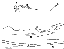
 Bimini offshore features. C marks regular blocks. E indicates ancient beach lines. F is the current shore. G is forested shore. See text for A, B and D. |
D.G. Richards, in a splendid article in the Journal of Scientific Exploration gives us a blow-by-blow account of the investigations (both amateur and professional) of Bimini waters. It is a curious panorama of wild claims by adherents of the Cayce-inspired Atlantis searchers and the knee-jerk academic scoffers - both of which go overboard! Be this as it may, our purpose here is the recording of some of the features near Bimini that Richards thinks are still anomalous.
Three of these are located at A, B, and D in the accompanying drawing, which is based on an aerial photo taken at 6,000 feet. A is a 90 bend in the renowned "road." This bend is decidedly anomalous for a beachrock formation. B consists of a parallel row of stones. D is made up of regularly spaced piles of stones and extends over 1� miles, cutting diagonally across ancient beach lines.
Richards also employed a satellite image of the area to locate other "regular" features, such as a triangle, a pentagon, and a sharp, right-angle corner with mile-long sides. Inspecting these regularities from a small boat, Richards found no obvious structures of any kind. Rather, the patterns were caused by sea grass and white sand. Even so, these superficial patterns may reflect the presence of artificial structures under the sediments. Certainly, if these regularities were observed in a photo taken over land, archeologists would rush to dig away the overburden. But this was Bimini, and everyone knows that no "high cultures" ever lived there!
(Richards, Douglas G.; "Archaeological Anomalies in the Bahamas," Journal of Scientific Exploration, 2:181, 1988.)