 |
Science Frontiers ONLINE No. 101: Sep-Oct 1995 |
|
|
The giant landslides of hawaii
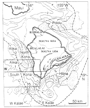
 The island of Hawaii. The offshore stipled areas show the major submarine landslides. Application of the distance scale proves their immense areal extents. Depth contours are in kilometers! The heavy dashed line marks the axis of the Hawaiian Deep. |
J. Moore et al have been mapping and sampling huge blocks of rock that slid off the sides of Mauna Loa in the socalled South Kona landslide. These blocks of lava and basalt are truly giants. One was measured at 10 kilometers in length, 300 meters in thickness. Some of these colossal chunks of rock slid 80 kilometers (50 miles) out to sea during the late Pleistocene. Imagine the tsunami (tidal wave) this landslide must have generated! (Moore, James G., et al; "Giant Blocks in the South Kona Landslide, Hawaii," Geology, 23:125, 1995.)
Comment. The South Kona landslide, or one like it, and the resulting tsunami might account for the curious distribution of sand dunes along the coast of New South Wales, Australia. See Science Frontiers #85.